The MacKay River The Great Outdoors |
home / | guestbook / | credits / |
Here's information on paddling the MacKay River. The page is still under construction, so check back often. I'll be adding pictures of the river, a description on how to get there, details on paddling it and in the future a more detailed map.
Note, we assume no responsibility for the accuracy or completeness of the information here and any use of it is entirely at your own risk. Paddling skills vary, the river can and will change, etc., so be PREPARED!!
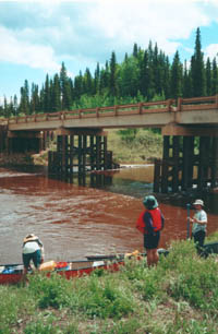
The MacKay River is a Class 1-3 river near Fort McMurray, Alberta. Water levels vary quite a bit, with the best paddling in early spring after runoff, or after a few weeks of rain. To run the the river, the flow rate should be at least 15m3/s, at which the river is very technical with a lot of maneuvering through rock gardens. At medium levels (20-25m3/s), the river becomes less technical, but there are some large standing waves, so be prepared to bail ;-). At high and flood levels (> 25m3/s), the standing waves can get large and taking on water is guaranteed.
In recent years, the water levels have been very low, with only a few short periods of medium level water. Click here for the current Flow Rate and Water Levels.
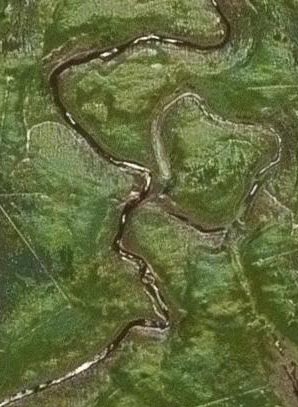
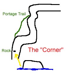
The river takes about 10 hours to paddle at low water levels; 4.5 hours from the put-in to the "corner", 2 hours from the "corner" to the confluence of the Dover, and 3.5 hours from the Dover to the take-out. For every 5m3/s of additional water, subtract approximately 30 minutes from the total time. The "corner" used to be by far the hardest rapid in the river, but over the last few years its mellowed out a bit. It's a narrow, sharp bend in the river where the water forces you to the outside wall and through a hole. It's then followed by a rock garden at lower water levels or a series of standing waves at higher water levels and then another sharp bend. There is a portage trail just before the corner, but if you miss it, you have to run it since the banks are steep and the water swift. The picture here is a rough sketch of what the "corner" looks like. Just ahead of the portage trail, there's a large rock in the water on the left hand side, although at high water levels, only a small portion of it may be visible.